

Oregon Issues
The 171,000 Independents(NAVs): Why OR-01 is Ready for a Change

OR 01 independent voters: what registration data can show
OR 01 independent voters is a common search phrase, but Oregon’s official registration category is nonaffiliated voter, often shortened to NAV. That label describes party registration; it does not reveal ideology, candidate preference, likelihood of voting, or willingness to change sides.
Any District 1 total needs a date and reproducible method. The Oregon Secretary of State elections statistics provide official registration data, while congressional boundaries must be checked separately. An undated headline number should be refreshed or removed.
Nonaffiliated is a registration status
A voter can be registered without choosing a political party. That administrative status should not be converted into labels such as centrist, moderate, persuadable, disengaged, or supportive of an independent candidate. Those are separate claims that require survey or behavioral evidence.
The same caution applies to comparisons over time. A change in NAV registration may reflect new registrants, party changes, address updates, removals, or administrative timing. A table should identify the reporting month and use the same category definitions for every period.
County totals do not equal the congressional district
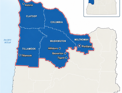
Oregon’s 1st Congressional District includes whole and partial county areas rather than a simple sum of every county mentioned in local coverage. The Census Bureau district map shows the congressional geography. Countywide registration totals cannot be treated as an exact district count when a county is split.
Beaverton, Tigard, and Portland references require address-level or precinct-level confirmation because city names and postal addresses do not necessarily align neatly with congressional boundaries. A method section should say which geography and district vintage were used.
A reproducible estimate
If an official district-level file is available, cite it directly and preserve the download date. If the count must be constructed from precinct data, document the source file, precinct-to-district crosswalk, excluded records, and calculation. If that work cannot be reproduced, describe statewide and county data without publishing a precise OR-01 total.
Readers can compare the boundary explanation with the site’s District 1 overview. The registration source and the boundary source should remain distinct so an updated map does not silently change the meaning of an older count.
Five interpretation cautions
Check the date, category definition, geographic unit, denominator, and source method. Also distinguish registered voters from ballots cast and population from eligible or registered voters. A percentage without its denominator can make a modest change appear larger or smaller than it is.
Official tools belong at the center
For this voter-data guide, the most useful article links readers to current registration statistics and clearly states what the data cannot answer. Registration deadlines and individual voter questions should always route to current official election tools rather than an archived blog summary.
A visible download date also tells readers when to seek a newer file. Archived totals may remain useful for trends, provided the article does not label them current.
A reliable OR 01 independent voters explainer treats NAV as a neutral registration category, dates every count, respects split-county geography, and publishes a method that another reader could repeat. It does not infer political beliefs from a checkbox on a registration record.
Primary and authoritative sources
Editorial note: This explainer summarizes public sources and distinguishes verified facts from proposals and commentary.
OR-01 nonaffiliated-voter data: a reproducible district method
A useful profile of OR-01 independent voters begins with Oregon’s official category: nonaffiliated voters. Registration status is an administrative fact, while ideology, issue preference, candidate preference, and likelihood of turnout are different questions. Keeping those concepts separate prevents a registration table from being interpreted as a survey.
The Oregon Secretary of State publishes registration data, and the Census Bureau publishes the official congressional-district map. Those sources answer different parts of the analysis. Registration data supplies counts by reporting unit and date; the map defines the 119th Congress geography that must be used when describing OR-01.
Define the category before counting
The label nonaffiliated voters should follow the terminology used in the state file. A reader may search for OR 01 independent voters, but the article should explain that “independent” in ordinary conversation is not necessarily the same as Oregon’s nonaffiliated registration category. A separate minor-party registration must not be folded into NAV without an explicit, documented rule.
Every published count needs the reporting month, file name, category label, and denominator. The denominator might be all registered voters, active registered voters, ballots returned, eligible residents, or voting-age population. These populations are not interchangeable, so the table heading should state exactly which one is being measured.
Match registration records to the district map
County totals cannot automatically become an OR-01 total because congressional boundaries may divide a county, city, ZIP code, or neighborhood. The Census Bureau’s OR-01 map establishes the district outline, while a precise registration estimate may require precinct-level data and a documented precinct-to-district crosswalk.
A reproducible method records the congressional map vintage, election precinct vintage, source download dates, any split precincts, and the rule used for records that cannot be assigned cleanly. If those inputs are unavailable, the responsible choice is to present county context without claiming an exact district figure.
Separate registration, participation, and opinion
Registration data can show how many records fall within a category at a point in time. It cannot show why a person selected that category, whether the person will participate in a future election, or which policies the person favors. Those questions require turnout files, surveys, or other evidence designed for that purpose.
Changes over time also need careful interpretation. A higher or lower NAV count can reflect new registrations, address changes, category changes, removals, district-boundary updates, or administrative timing. An article should describe the observed change first and avoid assigning a motive unless a separate source supports it.
Publish a district data table readers can audit
A transparent OR-01 table can include reporting date, geographic unit, category, count, denominator, percentage, source file, and calculation note. A second note should state whether the value came directly from an official district field or was constructed from smaller geographic records.
For OR 01 independent voters, a useful update log preserves earlier snapshots rather than silently overwriting them. That makes trend comparisons possible and alerts readers when a revised source file, new precinct plan, or new congressional map changes the method.
Use a neutral interpretation checklist
Before publication, verify five questions: Is the category defined? Is the geography truly OR-01? Is the denominator visible? Is the date current for the claim? Can another reader repeat the calculation? If any answer is no, the figure should be qualified or withheld until the method is complete.
This approach makes information about nonaffiliated voters useful without turning an administrative record into a claim about political identity. It also gives readers a durable way to evaluate later updates from the Secretary of State against the same district map and calculation rules.
A credible OR-01 independent voters resource is a dated data note, not a prediction. It names the official category, respects split geography, shows its denominator, distinguishes registration from turnout and opinion, and preserves the calculation so future updates can be compared on equal terms.
Official sources for this reference section
Serving Oregon’s 1st Congressional District
Oregon’s 1st Congressional District includes Clatsop County, Columbia County, Tillamook County, most of Washington County, and part of Multnomah County, including Portland’s west side.
These priorities affect Hillsboro, Beaverton, Tigard, Forest Grove, Astoria, Warrenton, Seaside, Tillamook, St. Helens, Scappoose, Vernonia, Rainier, Clatskanie, west Portland, and communities across northwest Oregon.
Related visual context
Source-credited images connected to the article’s policy, geography, or public-accountability themes.